Tree Walk at Seward Park
September 8, 2014

Seward Park, Seattle
“Today I have grown taller from walking with the trees.”
— Karle Wilson Baker, from 365 Days of Wonder: Mr. Browne’s Book of Precepts by R. J. Palacio
Earlier this summer when I walked the perimeter of Seattle, I passed by Seward Park without taking the time to explore it. So I returned on Friday to see what this popular city park was all about and to walk the 2+ mile road edging the “peninsula” that juts into Lake Washington. The city of Seattle has published a “Tree Walk at Seward Park,” and with this printout I set out to identify some of the magnificent trees in the park. Let me take you along on my jaunt through Seward Park.

View of Mount Rainier across lake Washington from Seward Park

Row of Bolleana Poplars along the parking lot

Leaves of the Bolleana Poplar

Garry Oak

Leaves of Garry Oak

Spider web

Madrona bark. According to the city brochure, “Seward Park is home to Seattle’s largest collection of Madrona trees.

Another Madrona with peeling bark. Madronas are native to the Pacific Northwest.

Most of the trees in Seward Park are native Douglas Fir trees.

The cones of the Douglas Fir have dragon-tongue-like protrusions jutting out from the cone bracts.

Sketch of Douglas Fir cone

Leaves and acorns from Northern Red Oak


Threadleaf Falsecypress

Traffic circle at Seward Park

Blue Atlas Cedar

The clusters of the Blue Atlas Cedar look like spiky beads on a bracelet

Coastal Redwoods

Leaf litter beneath the Coastal Redwoods


Port Orford Cedar

Trail through the trees, Seward Park

Off Trail
April 28, 2014
National Poetry Month. 28

Hiker dwarfed by Mount Rainier
Off the Trail
by Gary Snyder
We are free to find our own way
Over rocks — through the trees —
Where there are no trails. The ridge and the forest
Present themselves to our eyes and feet
Which decide for themselves
In their old learned wisdom of doing
Where the wild will take us. We have
Been here before. It’s more intimate somehow
Than walking the paths that lay out some route
That you stick to.
All paths are possible, many will work,
Being blocked is its own kind of pleasure,
Getting through is a joy, the side-trips
And detours show down logs and flowers.
The deer paths straight up, the squirrel tracks
Across, the outcroppings lead us on over.
Resting on treetrunks,
Stepping out on the bedrock, angling and eyeing
Both making choices — now parting our ways —
And later rejoin: I’m right, you’re right,
We come out together. Mattake, “Pine Mushroom,”
Heaves at the base of a stump. The dense matted floor
Of Red Fir needles and twigs. This is wild!
We laugh, wild for sure,
Because no place is more than another,
All places total,
And our ankles, knees, shoulders &
Haunches know right where they are.
Recall how the Dao De
Jing puts it: the trail’s not the way.
No path will get you there, we’re off the trail,
You and I, and we chose it! Our trips out of doors
Through the years have been practice
For this ramble together,
Deep in the mountains
Side by side,
Over the rocks, through the trees.
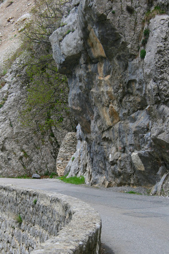
Hiking in France 2: Andy Goldsworthy Sentinels
May 27, 2013

Andy Goldsworthy sentinel near Authon
Andy Goldsworthy built three sentinels in this part of France, and we hiked to two of them — the Authon sentinel on Day 2 and the sentinel in the valley of Bes on Day 4. All are accessible by road, but Jean-Pierre felt that hiking to them would give us a better feel for the land elements that inspired Goldsworthy. The sentinels stand like guardians in the landscape. Although there is no mortar in the stacked stones, they are solidly built — sturdy and steadfast.
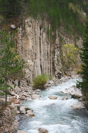
Day 2 was perhaps the most challenging day of hiking for me. We were on the trail from 9:00 a.m. to 5:30 p.m. Jean-Pierre had to make last-minute changes to our planned itinerary. We were to have sheltered for the night in one of the Refuges d’Art (huts that housed a Goldsworthy sculpture), but the mountain road was too muddy, and it was impossible to get a vehicle up there with our heavy bags and camping supplies. The adapted itinerary kept us hiking, sometimes off trail, and through more difficult terrain, for a longer-than-normal day. At times I felt like a mountain goat! My worst moment was slipping on a rock and stepping one foot into slimy, smelly swamp sludge. There was also a scary traverse across scree, short, but Jean-Pierre escorted us safely across one by one. I had a terrific workout, and the reward for the day’s efforts was seeing the first of Andy Goldsworthy’s sentinels.

Terrain Day 2

The Vancon Valley

I found this shell fossil in a rock along the trail. This part of France has many fossil sites.
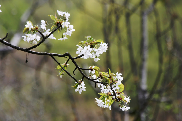
Cherry blossoms near our lunchtime picnic spot

Guide, Jean-Pierre

First glimpse of the sentinel near Authon

This sentinel is situated in an open space at a curve in the road.
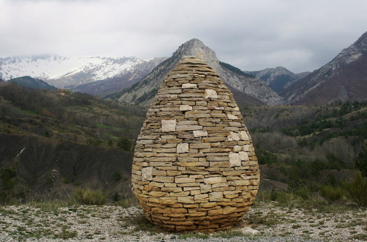
The shape of the sentinel mimics a distant mountain peak.


That’s me with the sentinel!

Sunset at the sentinel
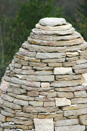
On Day 4, after another day of hiking, we saw a second Goldsworthy sentinel in the valley of Bes. This one was situated in a natural alcove in the looming rock. It felt like a tiny beacon in a dominating landscape, and yet it felt protected, sheltered and cocooned.
First glimpse of the second sentinel
The valley of Bes

Goldsworthy’s sentinel, valley of Bes

Again, the top of the sentinel echoed the shape of a distant peak.
Hiking Near Mount Rainier: The Naches Peak Loop Trail
September 13, 2012

Mount Rainier reflected in Tipsoo Lake near Chinook Pass on Hwy 410
I just had to take advantage of these last sunny days of summer to head to the mountains for a day hike. I love the Naches Peak Loop Trail for its stupendous views of Mount Rainier and its wildflowers as the trail meanders past several tiny sub-alpine lakes. This is an easy hike. Heading out on the trail just ahead of me was a family with a toddler in a backpack and a two-week old baby in a sling. I parked in the lot by Tipsoo Lake and headed clockwise up the trail so that I would have Mount Rainier in full view for the last part of the hike.
Here are some photos:

The sub-alpine meadows are studded with beargrass.

Tall trees with long shadows cast by the morning sun.

Lush green along melting rivulets

Beargrass and Queen Anne’s Lace with the Cascades in the background

The trail passes along several small lakes

Shards of ice and ground frost in the shady stretches of the trail

Busy bees, butterflies and birds along the trail

Tree silhouettes

Looking down on Dewey Lake from the Naches Peak Loop Trail

The Cascade Mountains with cascading blues

If you walk the trail clockwise, you’ll have this view of Mount Rainier on the latter part of the loop hike.

The trail passes yet another lake.

A weathered snag

The final stretch, heading back to Tipsoo Lake

Trail sign with Mount Rainier on the horizon
My Annual Hike at Ebey’s Landing
August 24, 2012

Hiking trail up to the bluff at Ebey’s Landing
When I have company from out-of-town, I like to take them to Ebey’s Landing, one of my favorite hikes on Whidbey Island. This loop trail provides a perfect slice of Pacific Northwest life — a ferry ride to get there, expansive views of Puget Sound and the Olympic Mountains, bucolic rural scenery, and a beach walk. It’s not too strenuous, and a breeze keeps you cool even on a hot, sunny summer day.
We experienced a special treat on this most recent hike — a plein air artist was working on a landscape in oil pastels. I always love to see artists at work.

Easel and trays of oil pastels at Ebey’s Landing

Steven R. Hill, plein air artist

An artist’s hands

Plein air art at Ebey’s Landing

View from Ebey’s Landing: a rural landscape with Mount Baker on the horizon

View out over Puget Sound

Looking down at the lagoon from the bluff at Ebey’s Landing

View of Olympic Mountains from across Puget Sound
A Prairie of Queen Anne’s Lace at the Union Bay Natural Area
August 9, 2012

A trail through the Union Bay Natural Area

The wet prairie of the Union Bay Natural Area is studded with Queen Anne’s lace.
The Union Bay Natural Area is a calming oasis in the heart of urban Seattle. It’s adjacent to the Center for Urban Horticulture and the Elisabeth C. Miller Library. The looped trail takes you past a wet prairie studded with Queen Anne’s lace and cornflower-blue chicory. There’s a pond, the shoreline of Lake Washington, lily pads and cattails.

Meadow with Queen Anne’s lace

Looks like a trap for insects!

A fork in the trail

Looking up — a lacy silhouette

Cornflower-blue chicory lining the trail

A place for a peaceful ramble

Great blue heron on the pond
Exploring Seattle On Foot: Long Walk # 2
July 1, 2011
“I have never found a city without its walkers’ rewards.”
— John Finley, “Traveling Afoot”

Common sight on urban walks, waiting for the walking sign
I so enjoyed my first long urban hike across the I-90 floating bridge (see yesterday’s post), that I’ve planned several more.
I set out on my second long walk, a journey of 8-1/2 miles, from my home to the Pike Place Market in downtown Seattle. I hiked 3-1/2 hours, including stops for photos and coffee and a picnic breakfast, along a route with scenic trails. Here are some highlights:

6:00 a.m. on the path at Green Lake: notice my long shadow in the early morning light

Summer morning at Green Lake

First stop: the Woodland Park Rose Garden at 50th & Fremont Ave N (unfortunately, the gates did not open until 7 a.m.)

I could still enjoy the roses viewed through my zoom lens!

Tree-lined walk down Fremont Avenue N

Waiting for the Interurban sculpture at Fremont & N 34th Streets. It's a Seattle tradition to decorate these statues.

Trees line the Ship Canal between the locks and Lake Union. My walk took me along the Ship Canal Trail.

Rowers on the Ship Canal

I crossed over the train tracks on W Dravus Street after stopping for coffee at Starbucks.

Mount Rainier seen from the Elliott Bay Trail

I took a short detour off the trail to check out the Amgen Helix Bridge.

The Amgen Helix Bridge is a pedestrian bridge to the Amgen campus.

Looking across Puget Sound to the Olympic Mountains from the Elliott Bay Trail

Totem pole along the Elliott Bay Trail

Small rose garden along the trail, with Spaceneedle in the background

Lovely yellow roses

The trail runs along the Olympic Sculpture Park.

I walked along Seattle's waterfront to the Hill Climb to the Pike Place Market.

Flower vendor at the Pike Place Market

Truck at the Pike Place Market
Thoreau Thursdays (11): Traveling Afoot
June 30, 2011
“I have learned that the swiftest traveler is he that goes afoot.”
— Henry David Thoreau, Walden

My well-worn hiking boots
Thoreau asserts that the fastest traveler is the one on foot. A seeming paradox. But when he goes on to explain, the mystery becomes clearer. In Thoreau’s day, to travel 30 miles by train cost the equivalent of a day’s labor. Thoreau could walk that distance in one day and arrive by evening. The person traveling by rail would first have to spend a day laboring to earn the fare, and then take the train the next day. Thus, the walking man arrived first and had a day full of the pleasures of the countryside.
The economics of walking as a form of travel have changed. The price of a tank of gas is still less than a day’s labor, and it transports us over distances that would take days traveling by foot. Today a better argument for slow travel might focus on the quality of the journey, the best way to travel. We might romanticize train travel over air travel, as Paul Theroux does in The Tao of Travel: “Every airplane trip is the same; every railway journey is different.” Or we might learn that the most rewarding journeys are on foot, as Gardner McKay does in Journey Without a Map: “I came to realize that I traveled best when I traveled no faster than a dog could trot.”
As I read more about walking, I began to wonder just how far I could walk in one day. I don’t even know the farthest distance I’ve ever walked in one day. I began to crave taking a long walk. A walk in the city would do:
“These are near journeys, but there are times when they do not satisfy, when one must set out on a far journey, test one’s will and endurance of body, or get away from the usual. Sometimes the long walk is the only medicine.”
— John Finley, “Traveling Afoot,” from The Pleasures of Walking, edited by Edwin Valentine Mitchell
I planned my pedestrian expedition for one of my days off work. Now that summer is here, the days are long. I had always wanted to walk across the I-90 floating bridge, so I set my goal to walk from my home in Green Lake to Luther Burbank Park on Mercer Island, a distance of about 14 miles.
I set out under cloudy skies at 7:00 a.m. and, after stopping to take photos and have a coffee and breakfast sandwich, I arrived at my destination at noon. It was a pleasurable walk but hard on my feet. I had to apologize to my poor feet for the extra 25 pounds I’m carrying. (Another good reason to lose some weight!) I could have walked more, as the day was still young, but I decided not to risk becoming more footsore. So I caught a bus home from the Mercer Island Park and Ride.
This experience of walking 14 miles gave me new appreciation for Thoreau’s energy and stamina. Maybe I can gradually work up to walking 30 miles in one day.
Here are some photos from my first long walk in the city:

7:00 a.m. I left my front door under cloudy skies.

I walked across the UW campus and saw this squirrel in a cherry tree on the Quad.

Rose garden by the fountain on the UW campus

Pale purple rose (UW Husky colors are purple and gold)

8:00 a.m. I cross the bridge over Ship Canal between Lake Union and Lake Washington.

Morning rowers on Lake Washington

Totem pole carved by Haida artist

Signpost to Arboretum Waterfront Trail

The trail skirts the parking lot at the Museum of History and Industry

The trail runs along Hwy 520 floating bridge. Floating walkways link Foster and Marsh Islands. A sign warns of water over the trail. I proceed carefully. It's very muddy on the islands.

I see a blue heron along the trail.

The heron flies off as I approach.

Here the trail is under 4 inches of water. I take my shoes off and wade across.

Wild iris flags

Reflections of the underside of the Hwy 520 floating bridge

Next I walk down through the Washington Park Arboretum.

Western Red Cedar boughs, Washington Park Arboretum

9:00 a.m. I am standing under this Golden English Oak, Washington Park Arboretum.

Maple leaves, Washington Park Arboretum

Peaceful amble through the Washington Park Arboretum

From the Arboretum, I follow Lake Washington Blvd to the shores of Lake Washington. It's now 10:00 a.m. and I am nearing Leschi Marina, with the Bellevue skyline on the opposite shore.

Willows on the shore of Lake Washington

11:00 a.m. After a break for coffee and a breakfast sandwich, I approach the I-90 floating bridge.

I-90 floating bridge over Lake Washington to Mercer Island

Signpost for I-90 Bridge Trail

Almost across, looking back toward Seattle. It's noisy on the bridge.

Luther Burbank Park, Mercer Island

Blackberry blossoms

Old vine on tree looks like a huge crawling insect, Luther Burbank Park

Earthworks, "The Source," in Luther Burbank Park

I take the bus home from the Mercer Island Park & Ride. I transfer in the bus tunnel, Pioneer Square Station.
TSNW Annual Snowshoe Event
March 6, 2011

TSNW group on the Cold Creek trail
Yesterday was the Team Survivor NW (TSNW) annual snowshoe event at Snoqualmie Pass in the Cascade Mountains, about 1-1/2 hours from Seattle. It was so much fun to play in the snow, which was deep this year. The beautifully groomed trail passed through snow-laden trees. The snow kept falling in clumps as the day warmed up. Here are some photos from the day:

Outfitted in my snowshoes; ready to roll.

The trail started at Hyak Ski area, a popular spot for downhill skiers.

Cross country skiers shared the Cold Creek trail with those of us on snowshoes.

Moss hung on the trees like green icicles.

The TSNW group looked like a human caterpillar following our guide, Sharon, in single file along the trail.

It was an overcast day, but occasionally a patch of sunlight illuminated the surrounding mountains.

Pinecones

Buds holding the promise of spring.

Heading into the home stretch

Just as we were ready to depart, the skies showed a few patches of blue.
Hiking Amidst Wildflowers
September 1, 2010

The Naches Peak Loop trail edged by wildflowers
My husband and I revisited another of my favorite hikes, the Naches Peak Loop trail by Chinook Pass in the Cascade Mountains. The last time I hiked here, a few years ago, it was a sunny day and we were treated to awesome views of neighboring Mount Rainier. This year, it was clear when we left Seattle, but the clouds were rolling in by the time we got to the trailhead. We hiked in the clouds and couldn’t see Mount Rainier from the trail. But the wildflowers were in bloom, and they made this hike worthwhile.

View of Mount Rainier from Hwy 410, as we drive to the trailhead.

The clouds were already rolling in on the slopes of Mount Rainier.

Signpost on the Naches Peak Loop trail near Chinook Pass

One of the tiny lakes just off the trail

Another small mountain lake along the Naches Peak Loop trail

Small stream cuts through a valley along the trail

Silhouette of my husband on the trail

The clouds roll in as we loop around Naches Peak.

The trees trap the moisture from the air.

Wildflowers along the trail

Crimson columbine

Paintbrush

Western anemone

Lupine

Wildflower

Wildflowers by Tipsoo Lake

